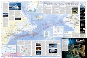
It is common knowledge that the giant ocean liner Titanic struck an iceberg and sank to the bottom of the Atlantic on the night of April 14-15, 1912. But where exactly did she sink? Could better maps
National Geographic's Battles of the Revolutionary War and War of 1812 map is rich with detail, illustrating significant battle sites and routes.The front side of the map illustrates the American War
The reference map of New Zealand uses National Geographic's Executive style with an antique-style color palette and stunning shaded relief. The map shows this island nation in great detail, from the s
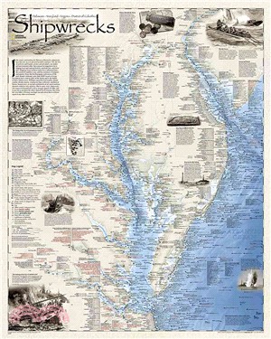
Developed by renowned marine archaeologist and accomplished author Don Shomette, and designed by award-winning cartographer Robert Pratt, Shipwrecks of the Delmarva is a stunning cartographic piece ba
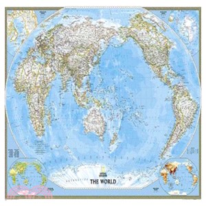
This unique view employs a new map projection to accentuate the Pacific Rim, and shows Oceania and Asia in close proportion to their actual size on the Earth. It brings Oceania and Asia into the cente
This computer-generated image of the Milky Way shows the entire galaxy in one perspective of a 3-D model compiled specially for National Geographic. The model incorporates the positions of hundreds of
This unique view employs a new map projection to accentuate the Pacific Rim, and shows Oceania and Asia in close proportion to their actual size on the Earth. It brings Oceania and Asia into the cente
This classic-style map of Japan shows political boundaries, major highways and roads, cities and towns, airports, and other geographic details. Thousands of place-names and exact borders are carefully
Our most popular United States wall map. Features all 50 States with insets for Alaska and Hawaii. All major cities, transportation routes, State boundaries, National Parks, inland waterways, and moun
Enjoy the accuracy and beauty of the latest world map from the cartographers at National Geographic. This map features the Winkel Tripel projection to reduce distortion of land masses as they near the
The reference map of New Zealand uses National Geographic's signature Classic style with blue ocean and stunning shaded relief. The map shows this island nation in great detail, from the subtropical N
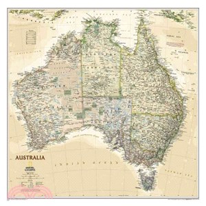
Completely redesigned and updated, National Geographic Maps' Australia Classic wall map is one of the most authoritative maps of the “Land down under".This new edition shows entire country with Tasman
This classic map of South America shows political boundaries, place names, airports, major roads and highways, and other geographic features for the entire continent.Map is printed on premium quality
This computer-generated image of the Milky Way shows the entire galaxy in one perspective of a 3-D model compiled specially for National Geographic. The model incorporates the positions of hundreds of
Our most popular United States wall map. Features all 50 States with insets for Alaska and Hawaii. All major cities, transportation routes, State boundaries, National Parks, inland waterways, and moun
This map of North America and South America shows political boundaries, major cities, and physical map inset of the area.Map is printed on premium quality paper stock, rolled, and packaged in a clear,
Our classic political map of Europe features country boundaries, place names, bodies of water, airports, major highways and roads, and much more.Map is printed on premium quality paper stock, rolled,
This map of North America and South America shows political boundaries, major cities, and physical map inset of the area.Map is printed on premium quality paper stock, laminated, rolled, and packaged
NEW! Highly accurate Australia executive style political map clearly shows state boundaries, place names, bodies of water, parks and preserves, and more. Includes inset maps for Tasmania and major Aus