‧ Waterproof ‧ Tear-Resistant ‧ Travel MapIn addition to the easy-to-read map on the front, the back includes: - Regional map - Airport diagram - Skytrain map - Express boat service map - Information
‧ Waterproof ‧ Tear-Resistant ‧ Travel MapIn addition to the easy-to-read map on the front, the back includes: - Regional map - Points of interest - Airport diagram - Metro map - Inset map of Central
• Waterproof • Tear-Resistant • Topographic MapThis Trails Illustrated topographic map for Virgin Islands National Park, and surrounding area on the island of St. John, US Virgin Islands. The map incl
• Waterproof • Tear-Resistant • Topographic MapNational Geographic's Trails Illustrated map of Uncompahgre Plateau North is a two-sided, waterproof map designed to meet the needs of outdoor enthusiast
• Waterproof • Tear-Resistant • Topographic MapNational Geographic's Trails Illustrated map of Uncompahgre Plateau South is a two-sided, waterproof map designed to meet the needs of outdoor enthusiast
‧ Waterproof ‧ Tear-Resistant ‧ Topographic MapNational Geographic's Trails Illustrated map of Mount Tamalpais and Point Reyes is a two-sided, waterproof map designed to meet the needs of outdoor enth
‧ Waterproof ‧ Tear-Resistant ‧ Travel MapNational Geographic's Caribbean DestinationMap strikes the perfect balance between map and guidebook and is ideal for a wide range of travelers. The map inclu
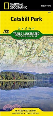
‧ Waterproof ‧ Tear-Resistant ‧ Topographic MapCATSKILL PARK – Trails Illustrated MapNational Geographic's recreational map of Catskill Park is a two-sided, waterproof map designed to meet the needs o
‧ Waterproof ‧ Tear-Resistant ‧ Travel MapIn addition to the easy-to-read map on the front, the back includes: - Regional map - Points of interest - U-Bahn (subway) map - Airport diagram - Inset map o
‧ Waterproof ‧ Tear-Resistant ‧ Travel MapIn addition to the easy-to-read map on the front, the back includes: - Regional map - Points of interest - Airport diagram - City Rail map - Information on tr
‧ Waterproof ‧ Tear-Resistant ‧ Travel MapIn addition to the easy-to-read map on the front, the back includes: - Regional map - Points of interest - Airport diagram - Information on transportation, ti
‧ Waterproof ‧ Tear-Resistant ‧ Travel MapIn addition to the easy-to-read map on the front, the back includes: - Regional map - Points of interest - Inset map of Mitte - U-Bahn and S-Bahn public trans
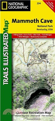
‧ Waterproof ‧ Tear-Resistant ‧ Topographic MapTopographic map for Mammoth Cave, and surrounding area in west-central Kentucky covers the area in and around the cave.The map includes the Green River,
‧ Waterproof ‧ Tear-Resistant ‧ Topographic MapThis sectional map of Canyonlands National Park zooms in on the Maze District in the western area of the park. This map provides more detail of this area
‧ Waterproof ‧ Tear-Resistant ‧ Topographic MapThis Trails Illustrated topographic map for Arizona's Saguaro National Park and surrounding areas to the east and west of Tucson, is the perfect map for
‧ Waterproof ‧ Tear-Resistant ‧ Travel MapIn addition to the easy-to-read map on the front, the back includes: - Regional map - Points of interest - Airport diagram - Public transportation map - Inset
‧ Waterproof ‧ Tear-Resistant ‧ Travel MapThe front side is an easy-to-read road map with insets of: - Eugene The back includes: - Maps and information for Portland and Salem - Information for Crate L
‧ Waterproof ‧ Tear-Resistant ‧ Travel MapIn addition to the easy-to-read map on the front, the back includes a regional map , top attractions, airport diagram, inset maps for downtown Orlando and the
‧ Waterproof ‧ Tear-Resistant ‧ Travel MapIn addition to the easy-to-read map on the front, the back includes: - Regional map - Points of interest - Inset maps of Lower Manhattan and Midtown - Subway
‧ Waterproof ‧ Tear-Resistant ‧ Travel MapIn addition to the easy-to-read map on the front, the back includes: - Regional map - Points of interest - Metrorail and Metromover maps - Airport diagrams fo
‧ Waterproof ‧ Tear-Resistant ‧ Travel MapIn addition to the easy-to-read map on the front, the back includes: - Regional map - Points of interest - Map and information for Lake Shore Drive and Lincol
‧ Waterproof ‧ Tear-Resistant ‧ Topographic MapThis Trails Illustrated topographic map for Joshua Tree National Park and the surrounding area in California is the perfect recreational map for this fas
‧ Waterproof ‧ Tear-Resistant ‧ Topographic MapNational Geographic's Trails Illustrated map of Adirondack Park Old Forge/Oswegatchie is a two-sided, waterproof, topographic trail map designed to meet
‧ Waterproof ‧ Tear-Resistant ‧ Topographic MapThis Trails Illustrated topographic map for Everglades National Park and surrounding area is the perfect map for hiking, boating, paddling, biking, fishi
‧ Waterproof ‧ Tear-Resistant ‧ Travel MapNational Geographic's Four Corners Region DestinationMap strikes the perfect balance between map and guidebook and is ideal for a wide range of travelers. The
‧ Waterproof ‧ Tear-Resistant ‧ Topographic MapOur new detailed recreation map for the Boston Harbor Islands National Recreation Area is a two-sided, waterproof map which covers all 34 of the harbor i
‧ Waterproof ‧ Tear-Resistant ‧ Travel MapThe front side is an easy-to-read road map with insets of: - Portland - Bangor - Lewiston / Auburn - Augusta The back includes: - Maps and information for Por
‧ Waterproof ‧ Tear-Resistant ‧ Topographic MapBAXTER STATE PARK / Mount Katahdin – Trails Illustrated MapNational Geographic's recreational map of Baxter State Park / Mount Katahdin is a two-sided, w
‧ Waterproof ‧ Tear-Resistant ‧ Topographic MapThis Trails Illustrated topographic map for Hawaii Volcanoes National Park on the island of Hawaii, highlighting two of the world's most active volcanoes
‧ Waterproof ‧ Tear-Resistant ‧ Travel MapThe front side is an easy-to-read road map with insets of: - Athens - Augusta - Albany - Savannah - Brunswick / Jekyll Island - Columbus - Macon The back incl
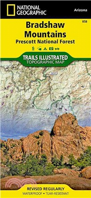
‧ Waterproof ‧ Tear-Resistant ‧ Topographic MapNational Geographic's Bradshaw Mountains Trails Illustrated topographic map is the most comprehensive available for outdoor enthusiasts of all types. Des
‧ Waterproof ‧ Tear-Resistant ‧ Topographic MapCovering all of Zion National Park, our Trails Illustrated map contains detailed topography with shaded relief, up-to-date trails, roads, and points of i
‧ Waterproof ‧ Tear-Resistant ‧ Topographic MapThis Trails Illustrated topographic map for Big South Fork National River and Recreation Area in southern Kentucky and northern Tennessee is the perfect
‧ Waterproof ‧ Tear-Resistant ‧ Topographic MapThe map includes Big Bend National Park, Portions of Big Bend Ranch State Park, Black Gap Wildlife Management ARea, the Chisos Mountains, Sierra del Carm
‧ Waterproof ‧ Tear-Resistant ‧ Topographic MapJam packed with over 500 miles of single-track and multi-use trails, our new National Geographic Trails Illustrated map for the mountain biking mecca of
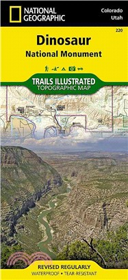
‧ Waterproof ‧ Tear-Resistant ‧ Topographic MapThis Trails Illustrated topographic map for Dinosaur National Monument, which straddles the state lines of northwest Colorado and northeast Utah, is the
‧ Waterproof ‧ Tear-Resistant ‧ Topographic MapThis two-sided map includes Black Canyon National Park in its entirety, and Gunnison Gorge Wilderness, and portions of Gunnison Gorge National Conservati
‧ Waterproof ‧ Tear-Resistant ‧ Topographic MapCompletely revised and expanded our Colorado National Monument Trails Illustrated map details the high use recreation areas throughout Colorado's Grand V